Posts

Showing posts with the label Centre County

Indian Steps Trail

Image
I've recently discovered that hiking after a root canal is not a fun time. However, I had to do it for the blog. Yesterday afternoon Scout and I went to hike Indian Steps Trail to the Mid-State Trail.  Indian Steps Trail is a 3.9 mile loop located near State College, PA. Located deep down a gravel road in the middle of Rothrock State Forest it's slightly difficult to find without using your GPS to get there.  The trail is mostly a vertical incline up the side of a mountain, or as some people would cal it, " A fairly large hill. " Mainly covered in leaves and sticks the trail is very rough and rocky and might be a challenging hike for those who aren't experienced hikers.  Once you've reached the top of the mountain you can either continue down the other side continuing on the Indian Steps Trail, or you can turn left or right and head to the Mid-State Trail.   For this hike I decided to go left and right and hike a few minutes each way...

Sunset Hike

Image
Normally, I wouldn't post about the same hike multiple times. However, last night's hike was the best hike I ever had! When it comes to hiking, I've always preferred to go in the afternoon when the sun is shining and you the views are as far as the eyes can see. Last night my friend Nate and I decided to hike Mount Nittany around sunset and it was the most amazing hike I have ever gone on.  As the sun was going down behind the clouds and over the mountain as we began our hike, I was rushing to get to the top because I was slightly afraid to hike in the dark . Unsure of the wildlife at night and unsure if we would be able to see the trail it was a rush against time. The higher up we got, the more I started to realize I was missing a whole different hiking experience. The way the sun shined down between the trees as it was setting, the way the wind blew ever so gently to keep you cool, but not cold, just the overall beauty of nature in the evening.  Once we finally ...

Spring Creek Canyon: State Game Lands 333

Image
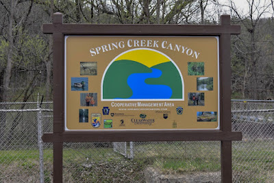
Today's hike was a relaxing 4 mile hike through the Spring Creek Canyon , along Spring Creek. This hike is located on Shiloh Road  off of I-99 near Bellefonte, PA. The hike is a 3 mile loop according to Alltrails.com . However for this hike we hiked from the starting point to the ending point straight ahead at rock road and along a state game lands trail.   The trail is a level, gravel path along the Spring Creek. When you first arrive to the trail, there are two signs informing you on the trail length , the trail width, the trial slope , and even the trail surface.  Fishing, running, biking, and hunting are other popular activities in the surrounding area.  This is a popular trail for fisherman and anyone who enjoys nature and taking their dogs for a walk. If you choose to hike along the State Game Lands there are benches placed around the creek if you plan on stopping to enjoy the creek, but be sure to keep your eyes open for signs so you don't...

Tussey Mountain

Image
Yesterday was the first truly nice day of the year in terms of weather. The sun was shining, the wind was blowing, it was a perfect day for a hike. If you're a fan of skiing , mini golf , go karts, skateboarding, or just being outside, chances are you've heard of Tussey Mountain . Along with outdoor recreational activities , Tussey Mountain is home to lots of trails/paths for hiking as well as mountain biking.  Located in parts of the Rothrock State Forest , there are and ample amount of trials and paths to explore. This hike was mainly along the Longberger Path as well as the Three Bridges Trail.   The Longberger Path is a primarily  rocky path. However the path is very smooth and well laid out with a clear direction of where to go and always keep you on the path. The trail itself is about a 2.5 mile hike from point to point that comes across many other trails along the way. One of these trails is the Three Bridges Trail. The Three Bridges Trail   is...

My First Hike

Image
I felt like it wouldn't be right to blog about hiking without sharing my first hiking experience! Interesting fact, I didn't go on my first hike until after I graduated from high school. It was June 2017 and a friend of mine at the time decided we should go hike Mount Nittany.  I had no idea where Mount Nittany was, how long it would be to hike, or even what to wear. My first time hiking I went hiking in a pair of jeans, beat up shoes, and a t-shirt! Needless to say, it did not go well! After finding our way to the beginning of the trail, it was time to begin our hike. At this time I was beginning to get into photography, so I had brought my newly purchased camera to snap some photos. I'm sure you can guess how well that went. New at hiking and new at photography, great combination! A few minutes into our hike I quickly discovered that hiking in jeans may not be the best pants to wear while hiking. It was a struggle to get to the top but I powered through a...

Millbrook Marsh

Image
Chances are if you're from central Pennsylvania you've heard of the Millbrook Marsh . For everyone else, you're probably asking,"What's so interesting about a marsh?" The Millbrook Marsh is a nature center located on Puddintown Road, in State College, PA. This nature center is a beautiful place to enjoy walking along the boardwalk to enjoy plants, a tiny creek, and all sorts of wildlife critters. The Marsh isn't necessarily a hike, however, if you're looking for a nice and relaxing day out with the family. The Millbrook Marsh is the perfect place to go. After enjoying the nature and wildlife around the Millbrook Marsh be sure to stop and have a picnic before you leave. With plenty of benches and pavilions around it's hard to find a reason to ever leave! The Millbrook Marsh is open 7 days a week from dawn until dusk, so there's always time in the day to stop by for a visit. Overall The Millbrook Marsh is a 62 acre park   so there...

Shingletown Gap

Image
Today's Hike was a sunny 3.5 mile hike through mud, rocks, and leaves at  Shingletown Gap , and along the Bald Knob Ridge Trail.  Unlike Mount Nittany, Shingletown Gap is a rough terrain trail. Alongside the main trail is a stream running through the Rothrock State Forest. The trail is very rocky and at times can be very muddy depending on the weather. However, along the trail is plenty of small wildlife such as squirrels, chipmunks, butterflies, and birds.   With an elevation of 597ft, Shingletown Gap, is slightly smaller than Mount Nittany when it comes to a vertical incline, but the view at the top is just as wonderful and there are plenty of different trails available for those who don't like the elevated hikes.  So if you're a fan of quiet hikes with your dog , Shingletown Gap is one of the best hiking trails in the area. When hiking this trail the chance of running into someone other than a mountain biker is very small. So be sure to wea...

Mount Nittany

Image
Over the weekend I decided to hike Mount Nittany with some of my friends. With large amounts of people, plenty of pets, and different wildlife, hiking Mount Nittany is one of my favorite things to do when the sun is shining and there's nothing else to do.  Mount Nittany has several different routes and trails that lead to different outlooks or just guide you through the mountain. From bottom to top Mount Nittany has a vertical incline of 600 feet. However, hiking top to bottom takes no more than slightly over an hour, assuming you'll stop to admire the view of Happy Valley from The Mike Lynch Overlook at the top of the mountain. The trails are very well marked off and maintained so you'll always know if you're going in the right direction. With trees marked blue and white along and station markers along the way to identify what trail you're on hiking. Mount Nittany is a must for anyone staying in Centre County , or just passing by Mount Nittany. So throw o...